The cold snap is expected to persist on southern Vancouver Island, with sub-zero lows forecast until at least Friday.
The forecast also calls for a 40 per cent chance of rain or flurries Wednesday and a 60 per cent chance Friday.
“The main story here really is it’s going to stay cold,” said Environment Canada meteorologist Cindy Yu. “Even though we are hinting at a chance of precipitation on Wednesday and Friday we’re not expecting any significant amounts.”
Evening temperatures are expected to be below freezing all this week, while daytime highs Tuesday and Wednesday predicted to peak at 3 C before a gradual rise ensues.
Strong weekend winds of up to 90 kilometres per hour died down Monday. Winds had buffeted a number of Vancouver Island communities on Sunday, contributing to a peak of about 15,000 customers without power, said B.C. Hydro spokesman Ted Olynyk.
Nanaimo was the hardest-hit with about 12,000 outages, while the West Shore and Esquimalt had a combined total of close to 2,700 and Oak Bay had nearly 390.
“In an event like this we had all crews available and working throughout the night,” Olynyk said.
The bulk of the outages had been repaired by Monday afternoon.
The City of Victoria reported little in the way of debris to clean up in the wind’s aftermath Monday.
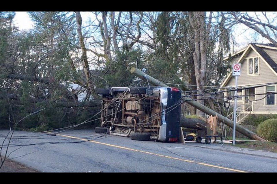
In Saanich, a truck on Union Road ended up tangled in power lines when strong winds sent a tree crashing down on Sunday, bringing the lines with it. No one was hurt.
In that case, a breaker tripped as it was supposed to and de-energized the wires, Saanich police said.
But the situation is a reminder that downed wires can be dangerous. Stay in your vehicle if wires are on it until utility crews tell you it is safe to leave, police said.
In Nanaimo, the heavy weekend snowfall created “a winter wonderland” that continued Monday, said David Myles, the city’s manager of roads and traffic services, but crews have been keeping pace with the task of clearing streets.
“The temperature’s just enough above zero where the roads are melting just the way we want them,” he said Monday afternoon.
Myles said the weight of the snow brought down some power lines, branches and a few trees Sunday, but there were no injuries.
He said the snow hit Nanaimo in force at about 1:30 a.m. Sunday and led to accumulations of up to 30 centimetres in places.
Some buses were rerouted because of road conditions. The City of Nanaimo urged drivers to use extreme caution Sunday and stay indoors until plowing crews were clearing and salting roads.
Vancouver Island University’s Nanaimo campus was open for evening activities Sunday and also opened Monday.
Nanaimo could see flurries on Tuesday.
Snow also fell in other parts of the Island on the weekend with Environment Canada saying that the Comox area received 10 to 14 cm of snow, Qualicum Beach received about eight to 10 cm, and Duncan about three. All have a chance of flurries on Tuesday, as well.
Some parts of Greater Victoria, such as Colwood and Saanich, received weekend snow while others were spared.
The wild weather has happened as Victoria unveils its blossom map. Cherry blossoms have started to burst open in the city.
The map shows when early and later blooming trees will be in flower.
Victoria’s blossom map: vicmap.maps.arcgis.com/apps/View/index.html?appid=bb2833176ff2419ab1170551d9877a29


