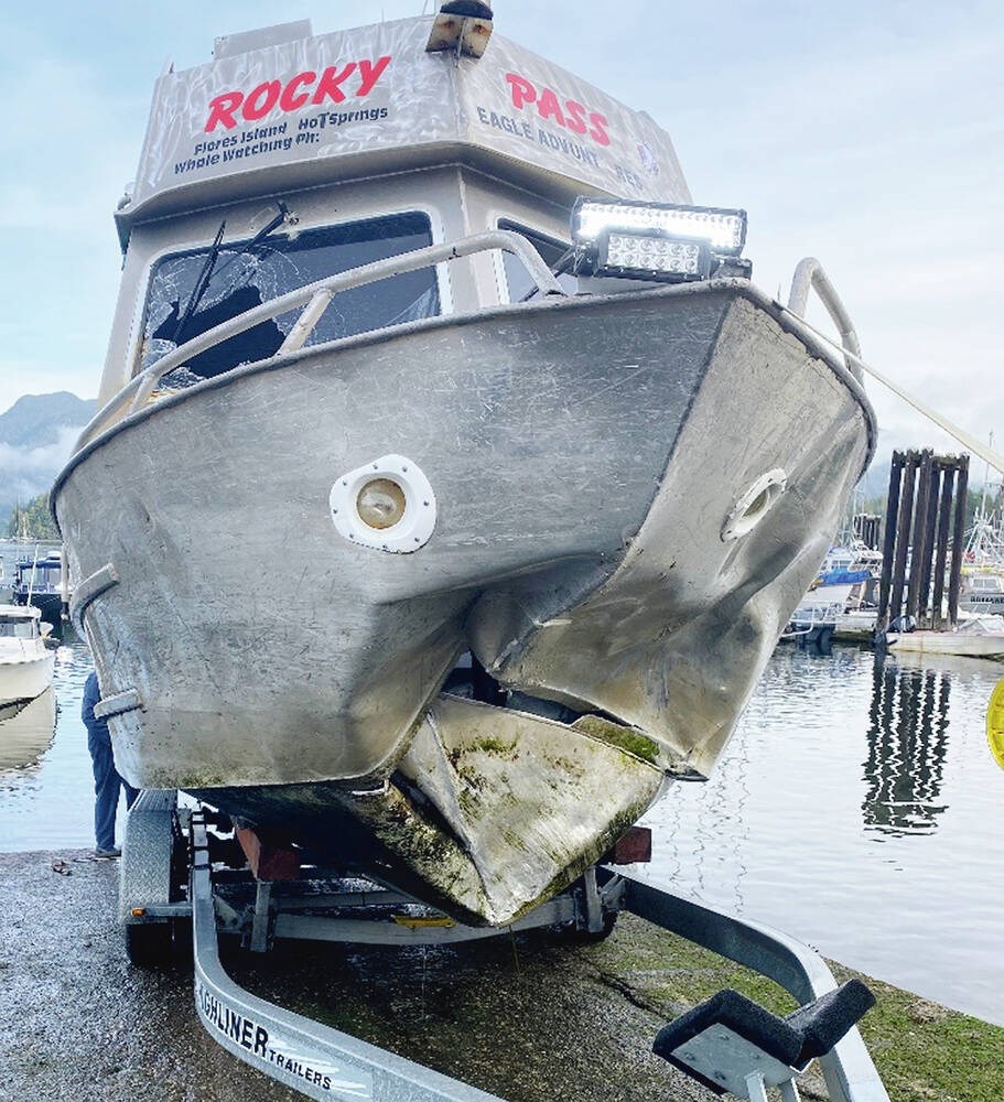
A water taxi operator’s speed and reliance on only one electronic navigational aid — GPS — contributed to the vessel hitting a rock in dense fog near Tofino last year, according to a Transportation Safety Board report on the crash released Monday.
On the morning of Jan. 25, 2022, the operator of the Rocky Pass, who had 20 years’ experience, was on the usual route from Tofino to Ahousaht with four passengers when the water taxi hit a rock that was directly in front of the aluminum-hull enclosed vessel.
The operator was traversing the shallow and rocky Coomes Bank at 22 knots — water taxis routinely proceed at 25 knots while transiting the route — while attempting to fix his temporarily frozen GPS. His radar, which had display-clarity problems, was not in use.
Momentarily losing the GPS display meant he could not view the vessel’s actual position. At about 9:28 a.m. when he looked up, it was too late and the vessel ran aground.
The impact punctured the bow and caused the vessel to come to an abrupt stop. The operator was thrown forward out of his seat and struck the front window, but was subsequently able to stop the engines and transmit a mayday call using the VHF radio-telephone with the assistance of one of the passengers.
The operator sustained serious injuries, as did three of the passengers. The fourth passenger sustained minor injuries. The passengers included a mental-health counsellor and cultural support worker, according to then Ahousaht Chief Greg Louie at the time.
Nearby vessels from the Coastal Nations Coast Guard Auxiliary and the Canadian Coast Guard responded. First aid was administered to the operator and the four passengers, and they were transported to hospital in Tofino.
The Coomes Bank shoreline route requires operators to navigate through many hazards, including rocks that protrude in low-tide.
Without radar, vessel operators must use their line of sight to detect hazards, but restricted visibility makes this more difficult, meaning “operators may need to proceed at slower speeds to ensure that the vessel can be safely stopped in time to prevent a collision,” said the report.
Travelling at 22 knots in dense fog reduced visibility to less than 20 metres, which meant the operator had approximately two seconds to react to any navigational hazards, said the report.
“As well, the operator was relying on a single navigational aid, the GPS, to maintain a safe passage because the vessel’s radar was not in use during the voyage. When the GPS display froze, the operator had no backup navigational aid to provide position information.”
Another factor in the crash might have been operator fatigue, the report said.
Ahousaht, with about 2,100 residents, relies on community members with vessels to transfer patients to larger towns with medical facilities in the event of medical emergencies, according to the report.
Medical evacuations from Ahousaht to Tofino are usually conveyed by local first responders to vessel operators in the area. It’s up to individual vessel operators to decide if they are able to conduct a medevac, but there was no schedule of availability at the time, said the report.
The operator of the Rocky Pass, based in Ahousaht, was preparing to go to bed when he heard a medevac request over the VHF radio-telephone at about 10:30 p.m. the night before the crash.
He waited approximately 20 minutes but when no one else indicated they would help, he responded, said the report.
He left Ahousaht with the patient, headed for Tofino Hospital, at about 11 p.m. and once at the wharf, he waited until 2 a.m. in case the patient needed transfer back to Ahousaht.
The operator caught some sleep on his boat “for a while” but was awake again at 6:15 a.m. for his previously scheduled trips for the day and departed for the first voyage to Tofino at 6:45 a.m. It was on the second trip from Tofino to Ahousaht that the vessel ran aground.
The unpredictability caused by the lack of a schedule to identify available operators for medevacs “makes it challenging for operators to prioritize their hours of rest and exposes them to the risk of fatigue,” said the report.
“Although it is not known if fatigue was a factor in this occurrence, performance decrements associated with fatigue are significant risk factors and predictors of occupational accidents and injuries including in the marine industry,” said the report.
Fatigue management is on a watchlist of key safety issues that the TSB has said need to be addressed to make Canada’s transportation system safer.
At the time of the crash, Paul Nixon, Tofino’s Canadian Coast Guard station officer, said the Ahousaht First Nation played a significant role in the rescue operation. The Ahousaht have a long history of being quick to respond to incidents ranging from float-plane crashes to sightseeing vessels in distress, and hikers and kayakers in trouble in the area.
Louie, speaking as a water-taxi owner, said it’s his understanding that water-taxi operators and boat owners are ensuring they have the proper number of navigation systems on each boat in addition to marine radios.
Some also have automatic identification systems that help identify other vessels, assist in finding a vessel’s location in search and rescue operations, and simplify the exchange of information between vessels.
Louie said many of the operators have “traditional knowledge” and experience with area waters, something they’ve enhanced with more modern technology over the years. Coast guard training offered to First Nations communities has also increased safety, he said.
The safety board report noted there is an alternative route between Tofino and Ahousaht along Calmus Passage, which is marked with navigation buoys. Along this route, the water is deeper and there are no rocks that protrude in low-tide. However, water taxis operating in the area do not typically use the route on regular transits or when visibility is restricted.
>>> To comment on this article, write a letter to the editor: [email protected]


