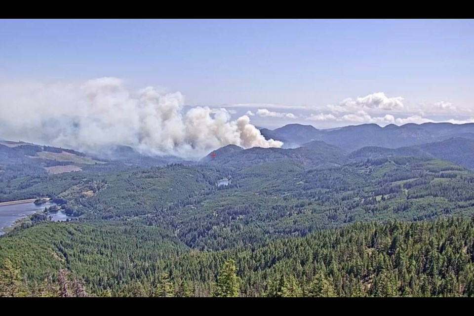
A wildfire at Sooke Potholes Regional Park first reported on Monday has grown to 50 hectares and is still burning out of control, says the Coastal Fire Centre.
The fire, initially reported as three hectares in size, was first spotted at 3 p.m. on Monday east of Sooke River, in the northeast section of the park. Visitors and campers in the area were evacuated as a precaution, and the park was closed.
Sam Bellion, fire information officer for Coastal Fire Centre, said the fire grew overnight due to sustained winds. “The winds did blow away some of the smoke, giving us a better aerial view of the fire.”
She said that there are three attack crews on site — consisting of 15 B.C. Wildfire Service personnel — as well as 10 CRD contractors.
A number of fixed-wing planes and helicopters are assisting but Bellion said the steep terrain where the fire is burning restricts their effectiveness.
The fire is believed to be human-caused.
A smoky-skies bulletin was issued for the Victoria area late Tuesday morning.
The fire was about five kilometres from the region’s water-supply area by Tuesday afternoon, but is not currently deemed to pose a risk to the watershed or the tree canopy within it, the CRD said in a statement, citing fire behaviour, terrain and wind direction.
It said the CRD is continuing to monitor the proximity of the fire to the water-supply area and any potential impacts on water quality that may result.
Fire-protection activity to protect the 20 square kilometres of watershed land can include ground patrols and air patrols with contracted aircraft, as well as limiting any operations that could cause sparks, it said, adding many staff members are trained in fighting wildfires.
The Sooke Fire Department was the first to respond to the fire on Monday but quickly determined additional resources were necessary.
Sooke Mayor Maja Tait said the fire is located in a “very challenging” area. “Crews have been working throughout the night with at least three helicopters.”
She said a call had been made to deploy water tankers but the steep terrain does not make it the most ideal suppression tactic.
An emergency command centre has been set up for resources sent by the municipality’s mutual-aid partners. Municipal employees have been told it’s “all hands on deck” to aid in the firefighting efforts, Tait said.
There are no structures in the area, but Spring Salmon Place Campground, operated by the T’Sou-ke First Nation, was evacuated as a precaution, said the District of Sooke.
The district said anyone who had been staying at the campground can collect any belongings left behind by first checking in at the Sooke Potholes Gateway — at the park entrance. After checking in, they will be escorted to the campground, which is run by the T’Sou-ke First Nation.
“Best efforts will be made to provide support quickly while we respond to what may be a changing situation,” the district said in a statement. “Your understanding is appreciated.”
Sooke’s Monday night council meeting was cancelled so municipal staff could concentrate on providing support needed for firefighters or community safety, said Sooke spokesperson Christina Moog.
In the Bamberton area, a brush fire over the weekend that’s believed to have been human-caused prompted renewed warnings about dry conditions on the south Island.
Mill Bay Fire Rescue Chief Chris McInerney said the fire on Sunday was caught in its early stages thanks to a report from boaters in Saanich Inlet about 6 p.m.
He said fires can spread quickly with so little moisture in the ground. “If there’s a little bit of a wind or something that picks up, it makes it even worse.”
McInerney urged the public to be vigilant and report anything that could be a sign of a fire.
Weather for much of the Island is expected to be sunny and warm for most of the week, although temperatures are likely to be in the low 20s, closer to seasonal averages.
Duncan, Nanaimo and Courtenay all have a chance of showers on Wednesday.
The only other Vancouver Island fire on the Coastal Fire Centre map is a small blaze on the grounds of the Harmac mill at Duke Point that is also believed to be human-caused.
Nanaimo Fire Rescue led the initial suppression efforts, which are now in the hands of mill staff.
A fire in a motorhome Sunday afternoon on Highway 19 north of Lantzville and a Duncan structure fire Saturday evening that is being treated as suspicious were both extinguished.
Bellion said parts of the south Island continue to have an “extreme” fire-danger rating.
Rain in the area on Sunday wasn’t enough to affect the rating, she said, but a section of the mid-Island dropped from a high to moderate rating after a more extended rainy period on Sunday and on Monday morning.
Bellion said aside from bringing the fire-danger rating down, sustained rain can make a dent in the “duff” moisture code, which refers to materials below the top layer of the forest floor.
Environment Canada meteorologist Lisa Erven said Tuesday that Greater Victoria and much of the rest of the Island are expected to be cooler than in recent days, with temperatures around the low 20s.
Wind from Juan de Fuca Strait will make sites near the ocean even cooler, with highs in the upper teens.
Dry conditions are expected to persist, with no significant rainfall in the forecast, Erven said, although there’s a chance of a light shower Wednesday evening.
There has been lightning in other parts of the province but none is in the immediate Island forecast, she said.
The B.C. Wildfire Service said it relies on the public to help detect new wildfires.
Anyone who sees a wildfire is asked to report it by calling 1-800-663-5555 or *5555 on a cellphone, or via the B.C. Wildfire Service app, the service said.


