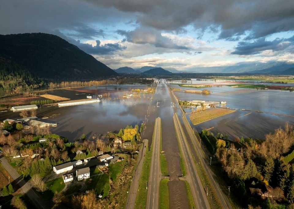
The images of what has happened in the lower Fraser Valley and elsewhere in B.C. are horrifying. Lakes where farms and communities stood a month ago, mudslides, washed-out highways and bridges, and evacuations prompted the B.C. government to declare a state of emergency on Nov. 17.
As much as the events and the extremity of the damage they caused may have taken us by surprise, they are not altogether unexpected.
Two massive floods have occurred on the Fraser River historically. The first one happened in the 1880s. The other happened in 1948.
I spoke to geologist John Clague, professor emeritus with Simon Fraser University’s Earth Sciences department and former director of the Centre for Natural Hazard Research, earlier this year. He mentioned then that there was no reason not to expect another major flood.
“I look at the diking system and wonder: ‘Is that going to be adequate for a 100-year flood?’” he said. “The system of protective dikes from Richmond all the way up the Fraser was essentially last upgraded after the 1948 Fraser River flood. We’re getting on to almost a century now after that flood, and there hasn’t been a lot of money put into upgrading that infrastructure.”
And he pointed out that while those upgrades haven’t occurred, “hundreds of billions of dollars or more of development have been put in on the Fraser River floodplain without a related expenditure on improving the protective dikes. To me, that’s a disconnect.”
The term “100-year flood” is a statistical estimate of how often a flood of a similar (massive) size would happen, on average, over the long-term. It’s not a prediction, however — a once-in-100-year flood could repeat after 10 years. In fact, research suggests that what is considered a 100-year flood today may occur far more frequently under climate change.
Given Clague’s comments, made 10 months ago, recent events were in some ways inevitable. The specific timing couldn’t have been foreseen, of course, and major floods have historically happened in the spring.
But the conditions that made this month’s events possible were in place.
The trigger that set them off was a month’s worth of rain falling in two days. Environment Canada reported that 24 communities across B.C. received more than 100 millimetres of rain between Nov. 13 and 15. Agassiz, Chilliwack, the Coquihalla summit and Squamish exceeded 200 millimetres. Hope received 252 millimetres.
It’s just the latest occurrence of the torrential autumn downpours that have been becoming increasingly frequent over the past two decades, as climate shifts and weather patterns become more extreme. It comes after another summer of widespread wildfires in the Interior, where many of the creeks and rivers feeding the Fraser originate.
Much of Merritt and Princeton were underwater. Multiple communities in B.C. lost critical infrastructure — water- and sewage-treatment plants, as well as their business districts and entire neighbourhoods. Thousands of people were stranded or had to evacuate.
Stretches of the province’s most productive farmland are under water in the Fraser Valley. Our local food supply will likely take years to recover, with all the associated food-security issues.
Landslides plugged the region’s highways and swept away people and vehicles. Four people have been confirmed dead and others remain missing at time of writing.
All major highways and rail lines from the Lower Mainland to the Interior were cut. Non-essential travel has been restricted on multiple affected highways. Even here on the Island, our transportation corridors remain affected.
The flooding also affected the south coast’s already struggling salmon populations.
Over the past 20 years, the province and municipalities have assessed the risk of various natural hazards the region faces. Those overturned the assumption, for example, that Victoria would fare better in an earthquake than Vancouver would.
They revealed the region’s coastal transportation vulnerabilities to earthquakes, tsunamis and sea-level rise. We’ve seen increasing numbers of severe wildfires, which exacerbate landslides and flooding. And as I wrote about last month, the entire province is already at risk for landslides, which are often triggered by heavy rain.
This month’s damage underscores just how vulnerable we are. It reminds us that even though some of us may see benefit in the short term by ignoring those risks, over the long term, we all pay.


