Residents in electoral areas around the Capital Regional District and Islands Trust can now consult a new series of maps that chart wildfire risk linked to the vegetation.
It’s a new approach for the two organizations, which said the mapping is developed “through a simple scientific approach that identifies where wildfires are most likely to impact developed areas.”
Electoral areas are communities situated outside of municipalities, and tend to be referred to as rural or unincorporated.
Severe wildfire activity around the province coupled with dry conditions over the summer raised residents’ concerns.
The CRD and Islands Trust said in a Tuesday announcement that their lands encompass a “patchwork” of natural and developed locations with a varying presence of fire-prone vegetation.
“Our communities are nestled in a rich, natural environment with mixed forests and vegetation that have different levels of risk due to changes in stewardship and fire-suppression practices over time,” said Paul Brent, chair of the CRD’s Electoral Areas Committee. “As we continue to live with climate change, we need to work together with landowners and community partners to prevent and be prepared for wildfire.”
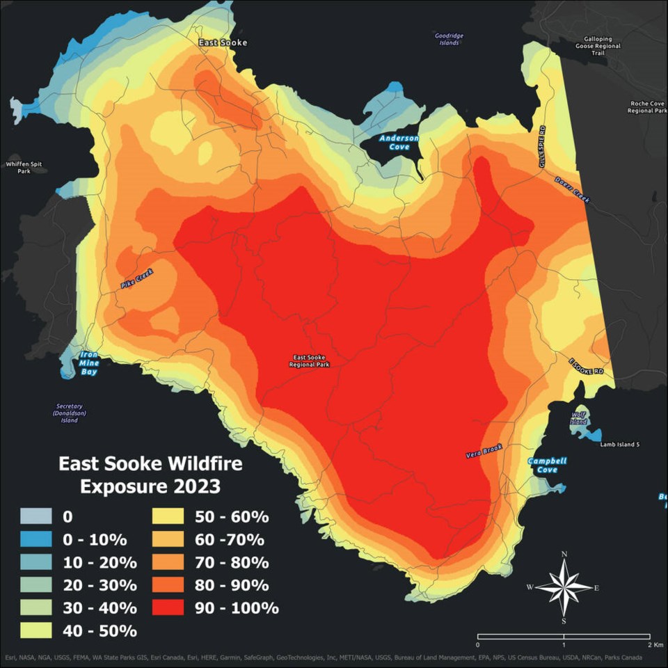
The new maps have been made for the Juan de Fuca Electoral Area, the southern Gulf Islands and Salt Spring Island.
Juan de Fuca district maps include Port Renfrew, Shirley, Otter Point, East Sooke and Willis Point, while the southern Gulf Islands maps feature Galiano Island, Mayne Island, Pender Island and Saturna Island.
Otter Point Volunteer Fire Department Chief John McCrea said that he considers the entire Otter Point area to be high-risk because of the “human factor.”
“We had people doing silly things like lighting fireworks during extreme fire conditions right at Otter Point in the middle of the night,” he said. “You can see where it caught some of the grass on fire, it’s just fortunate that it didn’t keep going.”
McCrea said there were three wildfires over the summer that closed in on the Otter Point area but were quickly contained by the B.C. Wildfire Service and local firefighters.
All of the maps have the same preface, which stresses that exposure to locations with a risk of wildfire because of vegetation is not the only factor to be considered.
“Ignition sources, weather patterns, slope, and construction materials contribute to wildfire risk but are not represented on the exposure map,” it says. “The most significant risk factors are under control of the homeowner within the home-ignition zone.”
Vegetation that can be a hazard includes the likes of conifer trees, which throw embers or produce intense heat, while broad-leaf trees are more fire-resistant.
“The more hazard fuels located within 500 metres [the distance range for embers] of a point, the higher the wildfire exposure,” the preface says.
Using FireSmart recommendations on your property can “dramatically decrease” the chance of damage from a wildfire, the announcement said, while the CRD can provide guidance about local emergency resources.
McCrea touted the effectiveness of FireSmart measures. Among them are keeping lawns short, ensuring that roofs and gutters are free from debris, cleaning off decks and trimming dry or dead branches away from houses or other buildings.
For FireSmart tips visit crd.bc.ca/service/fire-and-emergency-programs/fire-protection/firesmart or contact your local fire department.
>>> To comment on this article, write a letter to the editor: [email protected]


