Highway 14 between Jordan River and Port Renfrew is expected to reopen late Wednesday after the roadway suffered several washouts and culvert failures and damage from debris after the weekend’s atmospheric river.
“Road flooding happens all the time, so this isn’t anything new for us,” said Christopher Christmas, floor manager of the Renfrew Pub, on Monday.
He said the locals were “just hunkering down and waiting it out. It can be a lovely oasis out here, so most of us just kind of enjoy it.”
“It won’t be the last time this happens,” Christmas added.
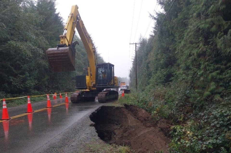
About 200 millimetres of rain fell across the west coast of the Island over the weekend. Water rushed down the hillsides onto Highway 14, overwhelming ditches and culverts and collapsing some road shoulders.
Port Renfrew isn’t completely cut off as it is connected to Lake Cowichan via the Pacific Marine Road. The province said its maintenance contractor, Emcon Services, has stepped up patrols to ensure that route remains passable until the ministry can get the highway open.
A 35-kilometre stretch of Highway 14 between Deering Road, just east of Port Renfrew, and Petrel Drive, west of Jordan River, is closed.
The Transportation Ministry said geotechnical work was completed on Sunday morning and crews were working as quickly as possible to address all the impacted sites.
Six separate areas of Highway 14 were damaged and need culvert replacements or basic roadwork due to heavy water flows. One site needs a cleanup and repairs after the rushing water caused pileups of rocks and trees.
The ministry is forecasting the highway will open late Wednesday to traffic.
This closure area includes very few private properties or residences, according to the ministry.
If access to a property is needed, the only area currently impassable is at Loss Creek.
Those wishing to access homes on the west side of Loss Creek would need to travel the Pacific Marine Road through Port Renfrew.
Anyone wanting to access homes on the east side of Loss Creek would need to co-ordinate with traffic control and maintenance contractor personnel at the closure point near Jordan River.
The ministry said it is recommending that people with recreational properties in the area wait until the highway is open to avoid unnecessary challenges and delays.
Rainfall warnings were lifted Sunday afternoon for western, eastern and inland Vancouver Island. The B.C. River Forecast Centre also lifted its warnings for stream flows on Monday, but added it will continue to monitor waterways as rain tapers to drier weather.
After being closed to the public Saturday, the Sooke Pot Holes gateway reopened Sunday as water levels in the area receded to safe levels.
The west coast of Vancouver Island was the hardest hit by the atmospheric river, with Kennedy Lake receiving 318 mm of rain.
Tofino was hit with 218 mm, followed by Bowser (117 mm), Saturna Island (112 mm), North Cowichan (101 mm), Malahat and Port Alberni (99 mm), Courtenay (93 mm) and Salt Spring Island (86 mm).
Victoria Airport received 69 mm, while 68 mm was recorded at the Victoria Gonzales weather station.


